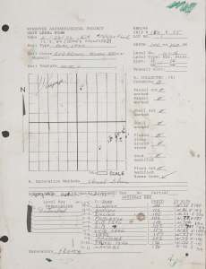
The Digital Library Center has been working with the FSU Department of Anthropology for several years now to digitize the materials created at the Windover dig site. We’re nearing the light at the end of the tunnel! However, as I loaded the last of the unit excavation forms, I realized something. I had absolutely no idea what these forms were! So, I sent off an email to Dr. Geoffrey Thomas for some clarification.
To start with, and something that I have never really thought about is that Archeology, the act of excavating, is an act of destruction. If they’re doing their jobs right, at the end of the dig, the site no longer exists. So, the hundreds of forms (For the Windover dig, over 600!), called Unit Excavation Forms, are used to record exactly what the archeologists were seeing as they dug the site. The site itself is divided into squares on a grid with each square having specific coordinates within the grid. Each form then corresponds to a specific square, or as they are called, unit.
Per Dr. Thomas, Unit Excavation forms’ primary role then, is to record the process of removal, layer by layer in each unit. Each form is labeled with information like the site name/number, the coordinates of the unit, the unit number that corresponds with a location on the grid, people working on that unit, and the level (depth) of the excavation. The workers then excavate in 10cm levels (ground – 10cm below surface = level 1) and so on to 90-100 cms = level 10. Each and every artifact is recorded as it is found and the workers make sure to mark the location within the unit, depth, and type of artifacts discovered. So, the unit forms and each level gets a form, then tell us what was found and where.

Pretty cool right? I also asked Dr. Thomas to think about what people will be able to learn now that these forms are online. Having the forms for the Windover dig online allows researchers and people interested in archaeology to gain information on, not only the process of archaeology but the specifics of the Windover site. If someone is interested in a particular burial and would like to find out the context of the burial (for example individual 90, a subadult with a large number of grave goods), Dr. Thomas, or the patron themselves, could look up burial 90 and have the excavation forms for that unit. This will allow Dr. Thomas and the researcher to see the position of the body and locations of each artifact in the burial, along with any pictures of the burial site if any exist. This will hopefully greatly increase the amount of interpretive power we have for examining the remains and the way they were treated at death.
Now that we know what they are, enjoy browsing through and getting a picture of the Windover site from the unit excavation forms. You will also find field notes and photographs as part of the larger Windover collection. Happy “digging”!
Note: We are in the process of digitizing and loading x-rays and photographs of burials at the Windover site. However, due to the nature of that material and NAGPRA guidelines, those materials will be in collections with restricted access. Look soon for instructions on how to apply to use these types of materials for research in DigiNole.